
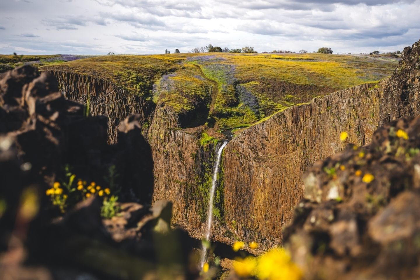
Situated above the city of Oroville, the North Table Mountain Ecological Reserve, more commonly known as simply Table Mountain, is a truly unique natural landscape. Formed by ancient lava flows, the mesa’s underlying basalt rock holds water on its surface, resulting in spectacular annual wildflower blooms, stunning vernal pools, and dramatic (but fleeting) waterfalls.
Discover the best of Table Mountain by lacing up and exploring its many trails!
Jump to: Best Time to Visit │ Travel Tips │ Phantom Falls │ Beatson & Phantom Falls Loop │ Many Waterfalls Cross-County Loop
When is the Best Time to Visit Table Mountain?
The reserve is a seasonal wonder. To see it at its best, plan your trip for:
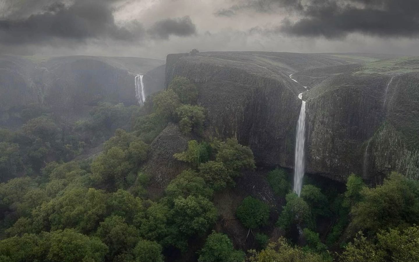
- Winter (December-February): Visit after heavy rains to see up to 14 flowing waterfalls and scenic vernal pools. Be prepared for significant mud and cooler temperatures.
- Spring (March-early May): This is peak wildflower season. Blooms typically start in March, peak in April, and fade by early May. Visit as early in the day as possible or on a weekday to avoid the crowds and enjoy a calmer experience.
Why Are There So Many Wildflowers on Table Mountain?
Wildflowers thrive on the North Table Mountain Ecological Reserve because of the Lovejoy basalt that covers the mesa and creates a dense, impenetrable layer.
This prevents water from seeping deep into the ground, and instead forms the vernal pools and soil conditions that allow wildflowers to flourish.
Trip Tips for Responsible Travel
Permits
Lands Pass Required: Every visitor 16 or older must carry a CDFW Lands Pass. (exempt if you hold a valid CA hunting or fishing license). Purchase online at the CDFW website, by phone at (800) 565‑1458, or in-person at locations wherever hunting and fishing licenses are sold.
Parking
Lot Parking: Use the gravel lot on the west side of Cherokee Road. Arrive early; space is limited.
Roadside Parking: Vehicles on the shoulder must be completely off the pavement. Parking on the pavement is strictly prohibited along the paved portion of Cherokee Road, beginning approximately 3.0 miles north of the intersection of Oregon Gulch Road (large parking turnout near the crest of Cherokee Road) to Derrick Road (map); violators are subject to towing.
Reserve Rules
- Stay on Trail: Walk only on established paths or durable surfaces like rock to protect fragile habitats.
- Leave No Trace: Trash cans and restrooms are only available at the parking lot. Pack out everything you pack in.
- Enjoy the View Only: Don’t pick or walk on the wildflowers
- Cattle: Respect grazing cattle by staying at least 300 feet away.
- Dogs: Allowed but must remain on-leash at all times.
- Drones: Prohibited without an appropriate film permit.
Phantom Falls
The hike to Phantom Falls is a classic Butte County experience. The falls flow during the rainy season, surrounded by carpets of wildflowers in the spring.
The Route
From the parking area, head northwest toward Ravine Falls. Start looking for a path leading downhill into the ravine. Depending on what season you go, Ravine Falls might be dried up but there is a clear signage for it when you get there. Then you will make your way up a rocky incline and across the rolling hills towards Phantom Falls.
After crossing the ravine, continue across the rolling hills toward the canyon edge. Even if Phantom Falls is dry, you’ll know you’ve arrived because of the panoramic views of the canyon.
Navigation
It’s easy to lose the trail in the open reserve. We recommend downloading the Avenza Maps app and the Phantom Falls map before you arrive (you can also view a PDF version here).
Key Info
Trail Difficulty: Moderate
Trail Length & Type: 4.2 mile out-and-back
Best Used: November — April
Trail Map: Phantom Falls Trail map
Beatson & Phantom Falls Loop
This loop offers a “greatest hits” experience of the reserve. You’ll see Phantom Falls plus four additional seasonal waterfalls. Wildflowers are abundant February through April, plus grazing cattle year-round.
Sturdy, waterproof hiking boots are highly recommended as this route involves cross-country travel over uneven terrain.
Key Info
Trail Difficulty: Moderate
Trail Length & Type: 6.7 mile loop
Best Used: Late February-April for wildflowers; winter for falls.
Trail Map: Phantom Falls Trail map (continue to Beatson Falls and then return to the Phantom Falls Loop trail)
Many Waterfalls Cross-Country Loop
The Many Waterfalls Cross-Country Loop is the premier route for waterfall seekers.
Taking you around Table Mountain during the rainy season, this loop will have at least nine waterfalls, with 14 flowing within a few days of a major rainstorm and all of them dry during the summer. It’s a fleeting beauty worth seeing.
This route is difficult, often muddy, and requires active navigation, so we recommend the Avenza Maps app and the Many Waterfalls Loop trail map before your hike so that you can follow the GPS coordinates in real-time.
Key Info
Trail Difficulty: Difficult
Trail Length & Type: 11.3 mile loop
Best Used: January-February (Waterfalls); February-mid-April (Wildflowers).
Trail Map: Many Waterfalls Cross-Country Loop map
Driving Directions
From Oroville: Take Hwy 70 North and exit at Grand Ave (Exit 48). Turn right (East) on Grand Ave for 1 mile. Turn left on Table Mountain Blvd, then a quick right onto Cherokee Road. Follow Cherokee Road for 6.3 miles to the reserve entrance.
From Chico: Take Hwy 70 South and exit at Grand Ave (Exit 48). Continue onto 4th St, turn left onto Grand Ave, and follow the directions above.