My wife and I set out in late February to hike the trails on Table Mountain. It was a beautiful sunny day shortly after a decent rain — the perfect time to take to the trails around the Many Waterfalls Loop up at Table Mountain.
Parking
Parking is available in a gravel lot on the west side of Cherokee Road. The lot has a limited number of spaces, so please plan to arrive early for the best opportunities to park.
No parking on the pavement is allowed along the paved portion of Cherokee Road, beginning approximately 3.0 miles north of the intersection of Oregon Gulch Road (large parking turnout near the crest of Cherokee Road) to Derrick Road (map). Vehicles parking on the shoulder must be parked completely off the pavement; violators are subject to tow.
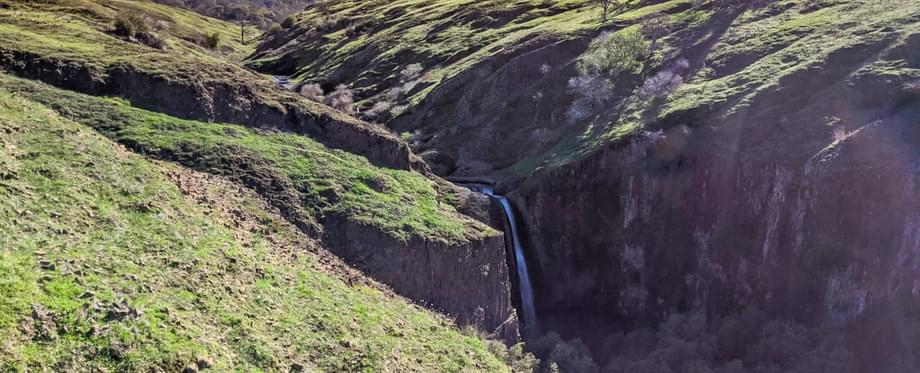
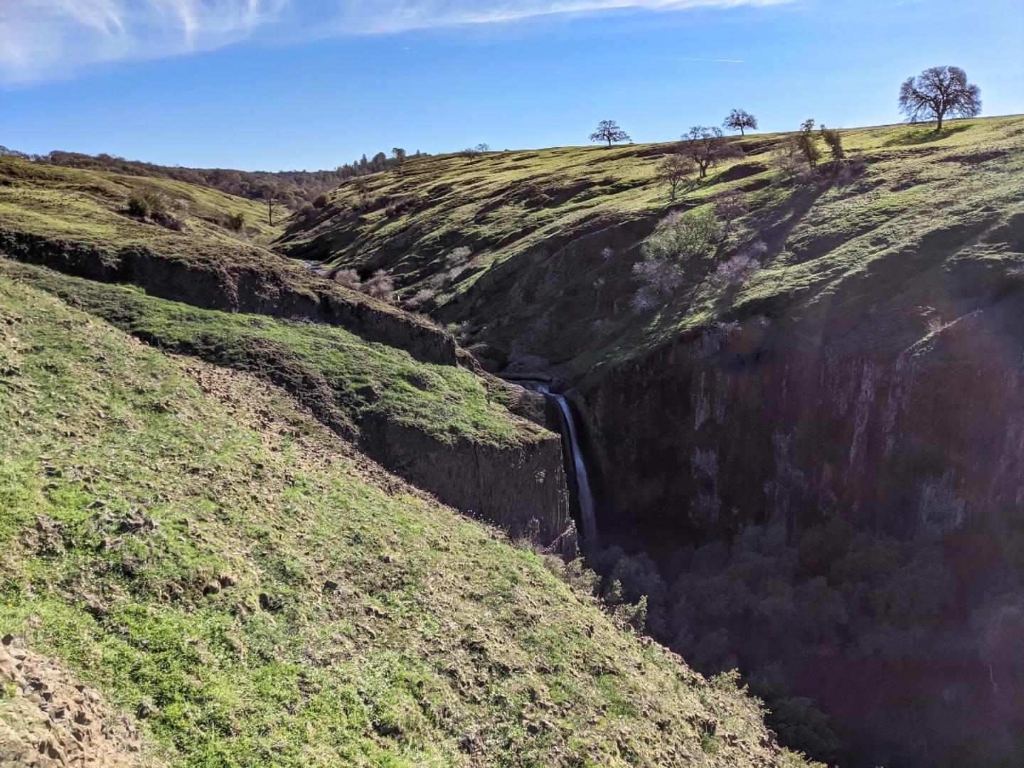
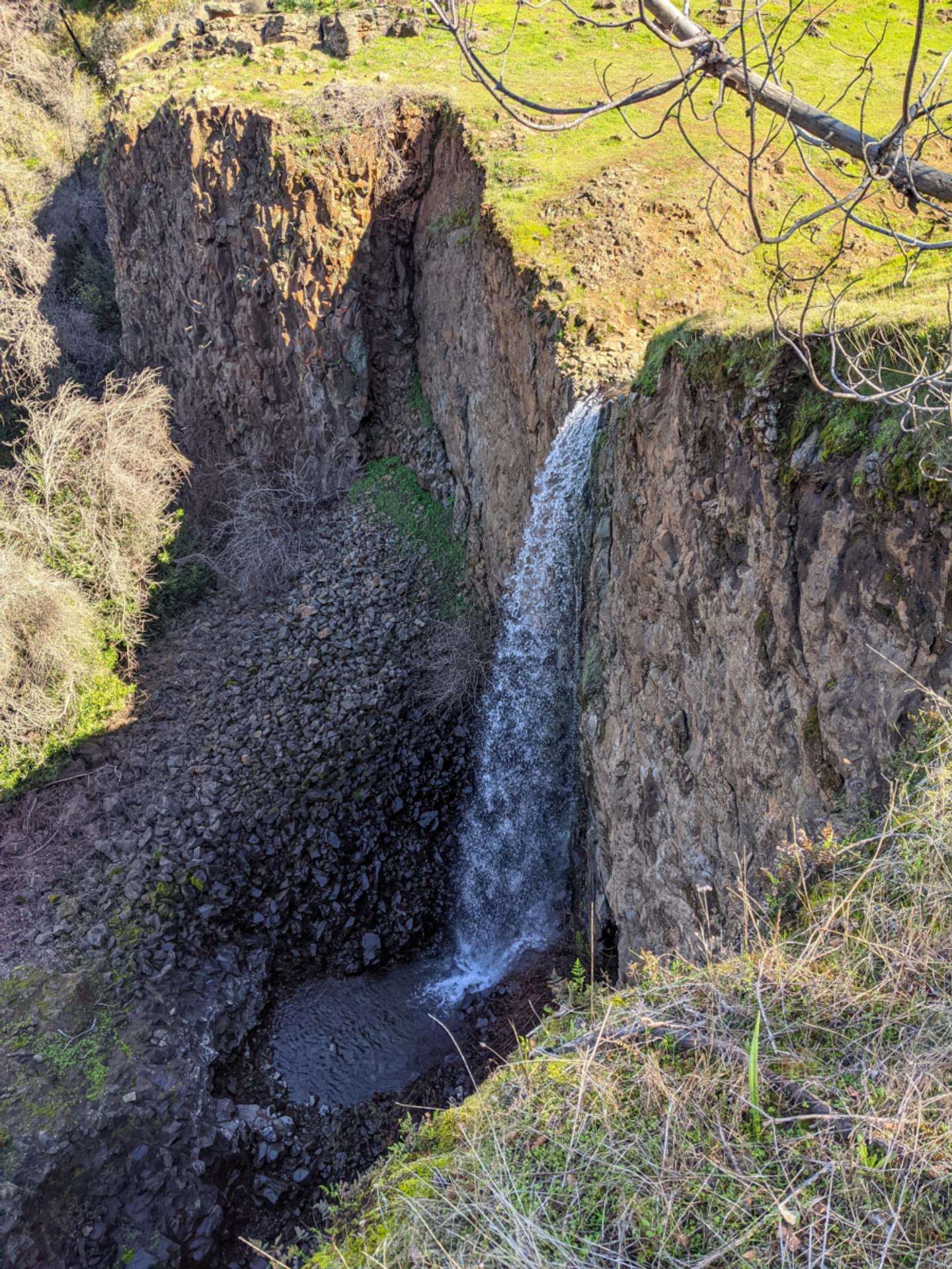
Beatson Falls
Beatson Falls, it turned out, was not the easy walk we anticipated it was going to be. Roughly halfway there, we hit a sign that suggested we could turn and travel through the countryside — seemingly without a trail — to get to Crevice Falls, but without a detailed map, that didn’t seem like the best choice. I asked my wife if she wanted to turn back, given that it was still a fair stretch to Beatson, but the sign indicated it wasn’t that much further, so once again we thought: “Why not; it’s only a little bit further ahead!”
What had begun as a delightful stroll through some rolling lowland hills, over which zig-zagged a few scenic water features, eventually turned into a long, slow uphill climb that took us further and further up. The last leg before Beatson Falls itself required sure footing on a rocky mountainside slope next to a precipice that would eventually show us a glorious view of the falls themselves as they dropped about 80 feet into the hollow below. It was a more strenuous hike than we’d intended to take, but the view was unlike anything I’ve yet seen in Butte County, and made every exertion worth the effort.
Trip Tips for Responsible Travel
Make sure to help keep the reserve clean by following other Leave No Trace principles
Dogs must remain on-leash at all times
Trash cans and restrooms are available only at the parking lot, so plan accordingly, and be prepared pick up after yourself and pack out all trash
Stay on established trails, or travel on durable surfaces (like rocks or packed dirt) when off-trail travel is needed
Enjoy the views OF the wildflowers, not IN the wildflowers (don’t pick or walk on the wildflowers)
Respect the grazing cattle by staying at least 300 feet away from them at all times.
Drones are not allowed on the reserve without an appropriate film permit
Lower Ravine Falls
From there, we weren’t sure what to do. Going back the way we came seemed like a long haul, and from the limited map we had, it appeared we might be able to get back more easily if we climbed the steep pass to the plateau above us. Little did we know that an even better overlook of Beatson Falls would have awaited us if we’d simply headed to the left a short ways once we’d gotten up top, but instead we set with gusto across the grazelands, through several herds of curious cows, a few of which stared at us with unsettling intensity, and many more that mooed us on our way out of their territory. While the path here wasn’t so well-worn, it wasn’t long before we had gotten our bearings and confirmed with our map that we were headed in the right direction, and we set off through more grassland hills until hitting a sign for Lower Ravine Falls and Phantom Falls.
It was the direction we wanted to go, and once again we thought: it’s not much farther, let’s go take a look!
To get down to the gentle glade where Lower Ravine Falls actually rests, one has to go down quite a long, sloping trail. Thankfully it wasn’t especially steep, and we were greeted with another gorgeous view of this small, unassuming waterfall and the rocky hollow it spills into. Worth the extra legwork for sure!
Phantom Falls & Ravine Falls
But what goes down must again come up, and this is when we realized that we had failed to plan our movements as well as we should have. Though we’d set out early in the morning, the sun was beating down on us after 3 hours or so on the trails, and what had been a largely private journey with almost no co-hikers turned into a much more social journey as we passed people coming from Phantom Falls. The paths going forward were quite narrow, and as we would soon discover, mostly located on the sides of ravines that required us to climb or descend a considerable distance. Thankfully people were generally courteous and allowed us to pass, and we did the same if we found a good place to stand to the side.
We finally reached Phantom Falls after a fierce climb on a rock-laden path. The views were wonderful, though by this point we had passed the 5‑hour mark of our hike, one that had grown far longer and more difficult than what we’d initially planned on. We continued past Phantom Falls back toward the parking area, and conferred with some other hikers to find, much to our dismay, that there would be one more down-and-up crossing to get through. We set our exhaustion aside for one final push, and made our way down to Ravine Falls. By this time the trails had grown quite crowded, especially considering our close proximity to the parking area, so we opted not to try to wait our turn to get up close to the waterfall, instead pushing up the last ascent to more level ground. We walked the last stretch with a family and several very happy dogs (at a respectful social distance) back to the parking area.

All told, we walked about 9 miles over the course of 6 hours or so, a lot of which had been steeper than we’d imagined. We were exhausted but thrilled to have seen 5 fantastic waterfalls, a couple of beautiful gorges, and a seemingly endless number of green hills. The only thing we might have changed in retrospect was our level of preparedness for all there was to see. Hopefully, our experience can help you be more prepared on your own journey, be it just to Hollow or Phantom Falls, or through the whole cross-country Many Waterfalls Loop.
Hiking Tips
Choose the right time for your hike on Table Mountain. Spring is ideal, as it will showcase the natural beauty of the area with green grass, flower blossoms, and fuller trees. It’s also best to hike a day or two after a good downpour. It will make the goings significantly muddier, but the payoff of the healthy waterfalls will be worth it.
Wear good shoes and be prepared for less stable ground. This is really Hiking 101 stuff, but especially when it comes to the Table Mountain trails, good hiking shoes or boots are a must. There will be a lot of muddy terrain if you’re trekking to see the falls after the rain, and the paths are often covered over in large quantities of smaller stones. They provide traction on muddy paths but aren’t especially stable, so in addition to good shoes, you may want to make use of trekking poles or walking sticks to help keep your footing on the ascents and descents necessary to get to many of the falls.
Plan in advance what you’d like to see, go in with that plan in mind, and bring water and food accordingly, especially for longer hikes. You can really build your own adventure with the many sights at Table Mountain, so knowing how far you’d like to go will make your life a lot easier. Also try to build in some flexibility to your plans if you can. After all, you might be like we were and simply say, “Well, that one is pretty close — let’s do it!” when you see the next sign.
In Explore Butte County’s “Live Like a Local” series, Butte County locals are invited to share their experiences about the best places to go, see, and experience. “Hike Like a Local” is a specific LLL series focused on hiking trails in Butte County. This is the first piece in the series.
